September 6 2010 Labor Day: A day off from school and work! We decided to take a drive around Lake Towada to see what the whole thing looks like. This meant our usual drive up Oriase Gorge....a route, that without fail, leads to a little girl in the backseat whispering "I don't feel so well" and there is generally a delightful green tinge to her face. Perhaps it is a subconscious thing to stop at our favorite "parking area" (rest stop). Some day we are going to remember to bring some fishing poles.....
 Next, we stopped part way up the gorge so that I could take MY turn at being green around the gills. Went into the visitor center while there, and found pictures of wildlife we might see in the gorge....have never seen this, but will keep my eyes open.
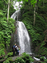
Shane and Andi wandered down to the rivers edge (of course) to see what is there.

 The first leg around the lake took us from lakeside, around many switchbacks, to the rim of the crater. No car sickness on this leg....I don't think Andi and I had anything more to give....plus we were chomping gum like mad! (my mother would not have been pleased..)

 The first leg around the lake took us from lakeside, around many switchbacks, to the rim of the crater. No car sickness on this leg....I don't think Andi and I had anything more to give....plus we were chomping gum like mad! (my mother would not have been pleased..)
 Anyway, this is the first view area. Below you can see the road we traveled up....well, not the road so much as the snowshed tunnels we came through.
 My husband, being ever compliant with boundaries, quickly climbed the fence to get a better view of the downward slope. Andi took a gander as well, though while clenching tightly to Shane's hand.

 At our next viewing area, there was an abundance of dragonflies. Pretty much the only insect that doesn't send Andi screaming off in terror. We had a great time standing still and letting the fairies in disguise come and perch.

 OK, enough playing around.....back to the tour. Above is the view from this stop. Here we found the educational information signs that all national parks have to carry, no matter what country you find yourself in. Of course it is in Japanese, but the pictures they have kind of make you feel like you can indeed read!
 Now, on the diogram below, lets not spend to much time wondering why this reminds us of something, but lets just focus on the cross section of the formation of the crater. (maybe it's just me who has her mind in the gutter....but I think not)
 So, the crater is 400 meters deep. That's 1312 feet. 0.24855 miles (if these are wrong, I blame the Internet....math and conversions are not my strong suit) At this point on the map below, we are at the bottom of the map. Having entered the tour from the left side from that road coming in from the lower left.
 Moving along, we stopped next midway around on the right side. Using the above map for reference, we missed the view area at the lower right....we were busy concentrating on the next set of switchbacks that took us off the rim and back to lakeside.
 Here we stopped for a rest, and a picnic lunch. There was a very nice parking area, lots of tables and benches and this pier where the ferry puts in. (it's plenty deep enough) There is a little beach, where ones toes can dangle a bit, but really, one should watch out for that last step....the water gets deep, fast! (and no, we didn't learn by experience....unless you count listening to the voices of our own parents from when we were children)
 My husband, being ever compliant with boundaries, quickly climbed the fence to get a better view of the downward slope. Andi took a gander as well, though while clenching tightly to Shane's hand.
 At our next viewing area, there was an abundance of dragonflies. Pretty much the only insect that doesn't send Andi screaming off in terror. We had a great time standing still and letting the fairies in disguise come and perch.
 OK, enough playing around.....back to the tour. Above is the view from this stop. Here we found the educational information signs that all national parks have to carry, no matter what country you find yourself in. Of course it is in Japanese, but the pictures they have kind of make you feel like you can indeed read!
 Now, on the diogram below, lets not spend to much time wondering why this reminds us of something, but lets just focus on the cross section of the formation of the crater. (maybe it's just me who has her mind in the gutter....but I think not)
 So, the crater is 400 meters deep. That's 1312 feet. 0.24855 miles (if these are wrong, I blame the Internet....math and conversions are not my strong suit) At this point on the map below, we are at the bottom of the map. Having entered the tour from the left side from that road coming in from the lower left.
 Moving along, we stopped next midway around on the right side. Using the above map for reference, we missed the view area at the lower right....we were busy concentrating on the next set of switchbacks that took us off the rim and back to lakeside.
 Here we stopped for a rest, and a picnic lunch. There was a very nice parking area, lots of tables and benches and this pier where the ferry puts in. (it's plenty deep enough) There is a little beach, where ones toes can dangle a bit, but really, one should watch out for that last step....the water gets deep, fast! (and no, we didn't learn by experience....unless you count listening to the voices of our own parents from when we were children)
Anyway, I wish I had a comfy chair....I could have rested out here for a loooooong time!
 Our picnic area.....complete with hundreds of dragonflies.....which are a good thing, as this means NO mosquitoes! Andi and I found this dragonfly down by the waters edge...a rock balanced on the branch of a tree, with the dragonfly perched on top!

 On we go for a ways. We didn't stop at the next village, as we've been there before (it's where we go for some of the festivals) but for reference, the village is located on the underside of that upper "toe" (or whatever you want to call it) Now from this view point (in red on the map....with our original entry point on the lower right) we get, yes, you guessed it, another look at the lake.....just be glad I didn't put all 80 pictures I took on this page.
 I am betting that in a good fall season the colors are spectacular. I bet also the little roads are very crowded.

 As we left the last overlook, we were coming back down to lakeside level. Through the trees we got a glimpse of some jade colored water. Knowing we were still looking at the lake, we just had to get out for a closer look. So we parked "Japanese style" (meaning we just pulled to the side of the road....even though there was no shoulder and got out...it happens a lot here), hopped out, found a game trail and followed it down. There was a little bit of a shore line (but the drop off was RIGHT there) so we were able to feel the water. It was warm. Much warmer than other areas of the lake where Andi's toes had dangled. Pretty neat to see that shade of water.
 After we got back in the car, we went around the next bend, to find this sign. Now we already know that there are bears in these woods.....we have just never seen the warning sign.....

 And finally, the end of a good journey! Lake Towada is among our favorite places to explore. There were many side roads branching out from the loop route. And they are beckoning.....
 Our picnic area.....complete with hundreds of dragonflies.....which are a good thing, as this means NO mosquitoes! Andi and I found this dragonfly down by the waters edge...a rock balanced on the branch of a tree, with the dragonfly perched on top!
 On we go for a ways. We didn't stop at the next village, as we've been there before (it's where we go for some of the festivals) but for reference, the village is located on the underside of that upper "toe" (or whatever you want to call it) Now from this view point (in red on the map....with our original entry point on the lower right) we get, yes, you guessed it, another look at the lake.....just be glad I didn't put all 80 pictures I took on this page.
 I am betting that in a good fall season the colors are spectacular. I bet also the little roads are very crowded.
 As we left the last overlook, we were coming back down to lakeside level. Through the trees we got a glimpse of some jade colored water. Knowing we were still looking at the lake, we just had to get out for a closer look. So we parked "Japanese style" (meaning we just pulled to the side of the road....even though there was no shoulder and got out...it happens a lot here), hopped out, found a game trail and followed it down. There was a little bit of a shore line (but the drop off was RIGHT there) so we were able to feel the water. It was warm. Much warmer than other areas of the lake where Andi's toes had dangled. Pretty neat to see that shade of water.
 After we got back in the car, we went around the next bend, to find this sign. Now we already know that there are bears in these woods.....we have just never seen the warning sign.....
 And finally, the end of a good journey! Lake Towada is among our favorite places to explore. There were many side roads branching out from the loop route. And they are beckoning.....